
STAGE 3
Flørli - Langavatn

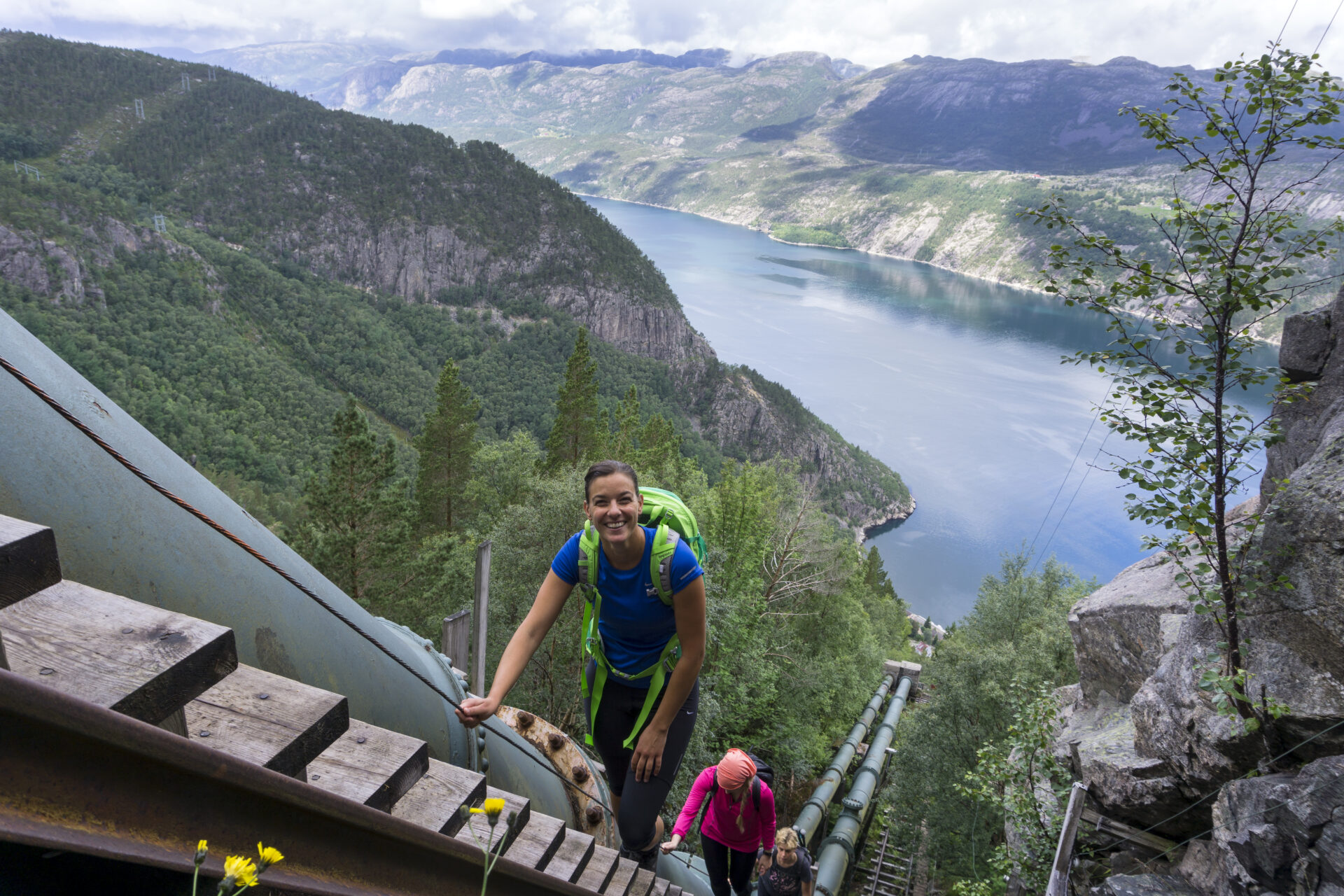


Hiking the world’s longest wooden staircase is an experience of a lifetime. 4,444 steps will lead you up from the fjord to 742 meters above sea level, in just 2 km, offering mighty views of the Lysefjord and the village of Flørli along the way. Suddenly, you are in the mountains. It is a very long hike to Langavatn. Start early and be prepared for a lot of elevation gain! The trail leads through very varied terrain. Exposed bedrock, sprinkled with boulders from the last ice age, bogs and ponds. This challenging hike offers a true wilderness experience. Most hikers highly underestimate the difficulty. Be well-prepared, as it can take up to 15 hours. In poor weather, we recommend a day hike in Flørli to avoid unnecessary risks on this demanding trail.
We recommend to hike the Lysefjorden Rundt Trail anti-clockwise. The information on this page is based on hiking west-east. Start the hike no later than 9 am. In June, check snow conditions. When hiking east-west, do not hike down the steep Flørli stairs. From the top of the Flørli stairs, you can hike down the safer Rallarstien Trail.
![]() On ut.no, Norway's hiking planner, you'll find detailed trail information. Use digital maps for navigation, and searching for cabins and hikes all over the country. Ut.no is a services offered to the public by the Norwegian Trekking Association (DNT).
On ut.no, Norway's hiking planner, you'll find detailed trail information. Use digital maps for navigation, and searching for cabins and hikes all over the country. Ut.no is a services offered to the public by the Norwegian Trekking Association (DNT).

| Difficulty | VERY DEMANDING (west-east) Demanding (east-west) |
| Distance |
17 km (west-east) |
| Duration |
8-10 hours (west-east) for experienced hikers. It is not uncommon to use up to 15 hours on the trail. 7-9 hours (east-west) for experienced hikers. Start no later than 8am. |
| Total elevation gain | 1600 (west-east) 550 (east-west) |
| Season | July - October |
| Link to digital hiking map | Ut.no/flørli-langavatn |
| GPX-file | Flørli-Langavatn (GPX) |
| More info |
Directions
You can take a ferry to Flørli. There are no roads to Flørli. Park at Lauvvik, Forsand, Songesand or Lysebotn quay.
If you hike from Langavatn, you first have to hike from Øygardstøl. See Langavatn-Kjerag-Lysebotn.
Public Transport
You can take a ferry to Flørli from Lauvvik, Forsand, Bratteli, Bakken, Songesand and Lysebotn.
If you hike from Langavatn, you first have to hike from Øygardstøl. See Langavatn-Kjerag-Lysebotn.
Accommodation
Are you planning to hike the Lysefjorden Rundt Trail in 2026?
By registering and sharing your schedule, you enable us to offer you free personalized advice on the feasibility of your hiking itinerary, considering both difficulty and logistics. It also provides us with data on visitor traffic and trail usage, which helps us make targeted improvements.
After your hike, you will receive a feedback form. We encourage you to share your experiences, as this information is vital for us to improve both the trail and the overall visitor experience continuously.
Lysefjord visitor guide
As you experience this majestic landscape, remember that your actions hold the power to protect and celebrate our unique destination for all who follow in your footsteps.

Respect Nature

Be Part of the Local Community

Stay Safe
