
ÉTAPE 3
Flørli – Langavatn

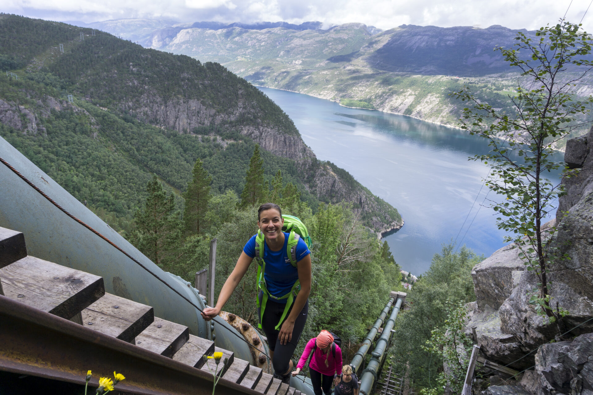


Gravir le plus long escalier en bois du monde est une expérience inoubliable. 4 444 marches vous mèneront du fjord à 742 mètres d'altitude en seulement 2 km, offrant des vues imprenables sur le Lysefjord et le village de Flørli. Soudain, vous voilà en pleine montagne. La randonnée jusqu'à Langavatn est très longue. Partez tôt et préparez-vous à un dénivelé important ! Le sentier traverse des terrains très variés : affleurements rocheux parsemés de blocs datant de la dernière période glaciaire, tourbières et étangs. Cette randonnée exigeante offre une véritable immersion en pleine nature. La plupart des randonneurs sous-estiment largement sa difficulté. Préparez-vous bien, car elle peut durer jusqu'à 15 heures. En cas de mauvais temps, nous recommandons une randonnée à la journée à Flørli afin d'éviter les risques inutiles sur ce sentier difficile.
Nous vous recommandons d'effectuer la randonnée du Lysefjorden Rundt dans le sens antihoraire. Les informations sur cette page concernent une randonnée d'ouest en est. Commencez votre randonnée au plus tard à 9 h. En juin, vérifiez les conditions d'enneigement. Si vous randonnez d'est en ouest, évitez de descendre les escaliers abrupts de Flørli. Du haut des escaliers de Flørli, vous pouvez emprunter le sentier plus sûr de Rallarstien.
![]() Sur ut.no, le planificateur de randonnées de Norvège, vous trouverez des informations détaillées sur les sentiers. Utilisez les cartes numériques pour vous orienter et rechercher des refuges et des randonnées dans tout le pays. Ut.no est un service offert au public par l'Association norvégienne de randonnée (DNT).
Sur ut.no, le planificateur de randonnées de Norvège, vous trouverez des informations détaillées sur les sentiers. Utilisez les cartes numériques pour vous orienter et rechercher des refuges et des randonnées dans tout le pays. Ut.no est un service offert au public par l'Association norvégienne de randonnée (DNT).

| Difficulté | TRÈS EXIGEANT (ouest-est) Exigeant (est-ouest) |
| Distance | 17 km (ouest-est) |
| Durée | Comptez 8 à 10 heures (d'ouest en est) pour les randonneurs expérimentés. Il n'est pas rare de mettre jusqu'à 15 heures pour parcourir le sentier. 7 à 9 heures (d'est en ouest) pour les randonneurs expérimentés. Commencez au plus tard à 8h. |
| Dénivelé total | 1600 (ouest-est) 550 (est-ouest) |
| Saison | Juillet – octobre |
| Lien vers la carte de randonnée numérique | Ut.no/flørli-langavatn |
| fichier GPX | Flørli-Langavatn (GPX) |
| Plus d'infos |
Instructions
Vous pouvez prendre un traversier à Flørli. Il n’y a pas de route vers Flørli. Garez-vous au quai Lauvvik, Forsand, Songesand ou Lysebotn.
Si vous partez en randonnée depuis Langavatn, vous devez d'abord partir d'Øygardstøl. Voir Langavatn-Kjerag-Lysebotn.
Transports publics
Vous pouvez prendre un traversier à Flørli depuis Lauvvik, Forsand, Bratteli, Bakken, Songesand et Lysebotn.
Si vous partez en randonnée depuis Langavatn, vous devez d'abord partir d'Øygardstøl. Voir Langavatn-Kjerag-Lysebotn.
Hébergement
Envisagez-vous de faire la randonnée du Lysefjorden Rundt Trail en 2026 ?
En vous inscrivant et en partageant votre emploi du temps, vous nous permettez de vous proposer des services. conseils personnalisés gratuits Nous évaluons la faisabilité de votre itinéraire de randonnée en tenant compte de sa difficulté et des aspects logistiques. Cela nous fournit également des données sur la fréquentation des sentiers, ce qui nous permet d'apporter des améliorations ciblées.
Après votre randonnée, vous recevrez un formulaire d'évaluation. Nous vous encourageons à partager votre expérience, car ces informations sont essentielles pour améliorer en permanence le sentier et l'expérience globale des visiteurs.
Guide touristique du Lysefjord
En découvrant ce paysage majestueux, n'oubliez pas que vos actions ont le pouvoir de protéger et de célébrer notre destination unique pour tous ceux qui suivront vos traces.

Respectez la nature

Faites partie de la communauté locale

Soyez prudent
