
第四阶段
兰加瓦滕 – 谢拉格 – 吕瑟博滕

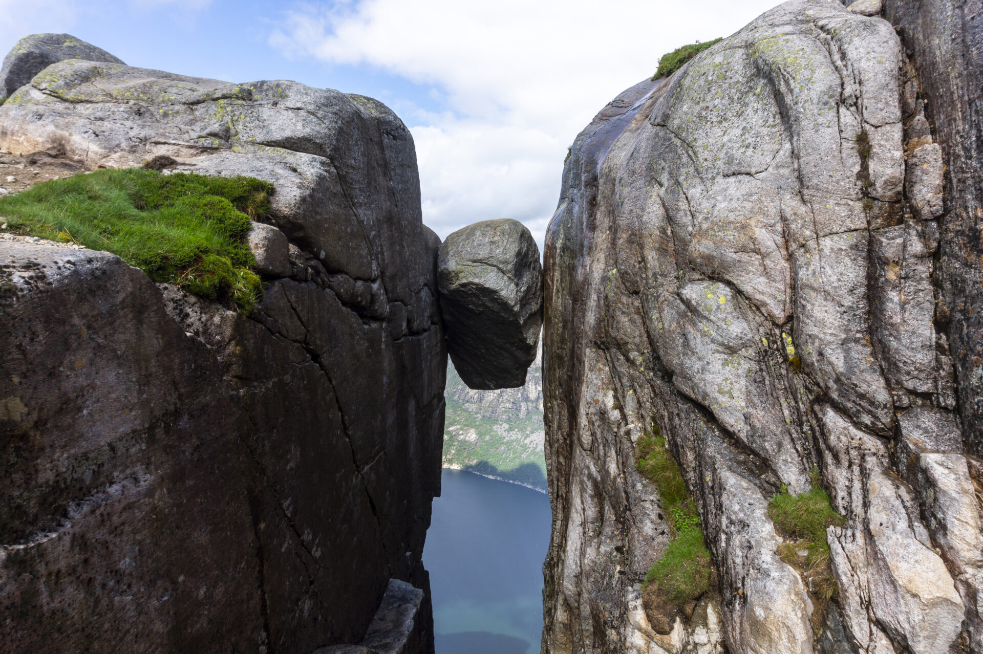


奇拉格博尔顿(Kjeragbolten),又称«吕瑟峡湾的雄伟巨石»,耸立于海拔984米处。站在这块巨石上,肾上腺素飙升,但沿途的自然风光同样壮丽,以至于岩石本身只是众多亮点之一。从朗加瓦特恩(Langavatn)出发,行程首先要经过裸露的岩石,然后才能到达山地高原边缘,俯瞰峡湾,欣赏水平和垂直方向的壮丽景色。完成这段行程后,您就到达了峡湾的尽头——舒适的小镇吕瑟博滕(Lysebotn)被巍峨的山壁环绕。在这里,您可以享用丰盛的三道菜晚餐,洗个舒服的澡,睡在柔软的床上,然后再出发,徒步探索吕瑟峡湾的北岸。.
我们建议您逆时针方向徒步吕瑟峡湾环线步道。本页信息基于东西向徒步,但您也可以选择顺时针或逆时针方向徒步此段步道。.
![]() 在挪威徒步旅行规划网站ut.no上,您可以找到详细的路线信息。使用数字地图进行导航,并搜索遍布全国的木屋和徒步路线。ut.no是由挪威徒步旅行协会(DNT)向公众提供的服务。.
在挪威徒步旅行规划网站ut.no上,您可以找到详细的路线信息。使用数字地图进行导航,并搜索遍布全国的木屋和徒步路线。ut.no是由挪威徒步旅行协会(DNT)向公众提供的服务。.

| 困难 | 要求高 |
| 距离 | 12.5公里 |
| 期间 | 7-8小时(南北方向) 8-9小时(南北方向) |
| 总海拔增益 | 550米(南北向) 850米(南北向) |
| 季节 | 七月至十月 |
| 数字徒步地图链接 | Ut.no/langavatn-kjerag-øygardstøl |
| GPX 文件 | 朗加瓦滕-谢拉格-厄加斯托尔 (GPX) |
| 更多信息 |
方向
没有通往朗加瓦特恩的公路。从西边过来,必须先从弗洛尔利徒步前往。 弗洛利-朗加瓦特恩.
从厄于加德斯托尔 (Øygardstøl) 出发,您可以将车停在步道起点。从斯塔万格 (Stavanger) 出发,最快捷方便的路线是驾车绕山,途经锡尔达尔 (Sirdal),翻越吕瑟韦根山口 (Lysevegen) 到达厄于加德斯托尔(约 2.5 小时)。此外,您也可以从劳维克 (Lauvvik)、福桑 (Forsand) 和松厄桑 (Songesand) 搭乘渡轮前往吕瑟博滕 (Lysebotn),然后驾车前往。.
渡轮运力有限,需要提前预订(参见公共交通)。.
由于积雪,通往 Øygardstøl 的道路从 11 月到 5 月中旬封闭。.
Øygardstøl 的停车费为 250 克朗。如果您想过夜停车,请与停车管理员联系。.
公共交通
没有公共交通工具可以到达朗加瓦特恩。从西边过来,必须先从弗洛尔利徒步前往。 弗洛利-朗加瓦特恩.
吕塞博特恩
科伦布斯——高速渡轮
渡轮从劳维克 (Lauvvik)、福桑 (Forsand)、松格桑 (Songesand) 和弗洛利 (Flørli) 出发,往返于吕瑟博滕 (Lysebotn)(全年)。.
SBK 基地
Lysebotn – Øygardstøl 的班车。.
奇拉格快车巴士
来自斯塔万格。.
您计划在 2026 年徒步吕瑟峡湾环线步道吗?
通过注册并分享您的日程安排,您可以让我们为您提供服务。 免费个性化建议 我们会评估您徒步行程的可行性,包括难度和后勤保障。此外,它还会向我们提供游客流量和步道使用情况的数据,帮助我们进行针对性的改进。.
徒步结束后,您将收到一份反馈表。我们鼓励您分享您的体验,因为这些信息对我们不断改进步道和提升游客整体体验至关重要。.
吕瑟峡湾游客指南
当您欣赏这片壮丽的景色时,请记住,您的行动拥有保护和颂扬我们这片独特之地的力量,让所有追随您脚步的人都能受益。.

尊重自然

成为当地社区的一份子

注意安全
