
STUFE 4
Langavatn – Kjerag – Lysebotn

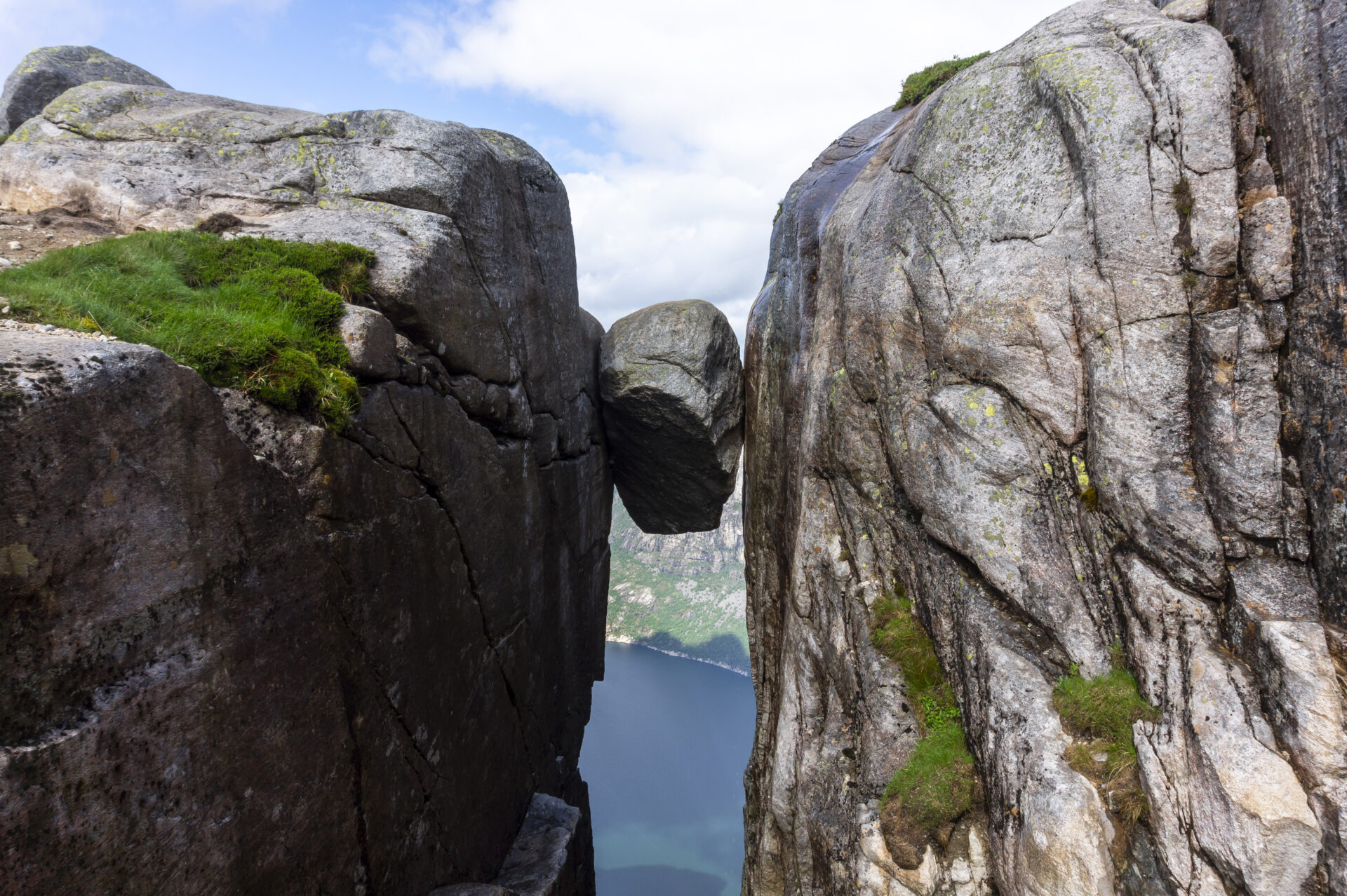


Der Kjeragbolten, auch «Majestät des Lysefjords» genannt, erhebt sich 984 Meter über dem Meeresspiegel. Auf dem Felsblock zu stehen, sorgt für einen echten Adrenalinkick, doch die Natur entlang des Weges ist so spektakulär, dass die Felsformationen selbst nur eines der Highlights darstellen. Von Langavatn aus führt die Wanderung zunächst über blanken Fels, bevor man den Rand des Bergplateaus erreicht, das den Fjord überblickt und sowohl horizontale als auch vertikale Ausblicke bietet. Nach dieser Etappe ist man am Ende des Fjords angekommen – das gemütliche Städtchen Lysebotn liegt eingebettet zwischen mächtigen Felswänden. Hier kann man sich bei einem Drei-Gänge-Menü verwöhnen lassen, eine wohltuende Dusche genießen und in bequemen Betten übernachten, bevor man zur Wanderung an der Nordseite des Lysefjords aufbricht.
Wir empfehlen, den Lysefjorden Rundt Trail gegen den Uhrzeigersinn zu wandern. Die Informationen auf dieser Seite beziehen sich auf eine Wanderung von West nach Ost. Es ist jedoch möglich, diese Etappe in beide Richtungen zu wandern.
![]() Auf ut.no, Norwegens Wanderplaner, finden Sie detaillierte Informationen zu Wanderwegen. Nutzen Sie digitale Karten zur Navigation und zur Suche nach Hütten und Wanderungen im ganzen Land. Ut.no ist ein Service des Norwegischen Wandervereins (DNT).
Auf ut.no, Norwegens Wanderplaner, finden Sie detaillierte Informationen zu Wanderwegen. Nutzen Sie digitale Karten zur Navigation und zur Suche nach Hütten und Wanderungen im ganzen Land. Ut.no ist ein Service des Norwegischen Wandervereins (DNT).

| Schwierigkeit | Anspruchsvoll |
| Distanz | 12,5 km |
| Dauer | 7-8 Stunden (Süd-Nord) 8-9 Stunden (Nord-Süd) |
| Gesamter Höhengewinn | 550 Meter (Süd-Nord) 850 Meter (Nord-Süd) |
| Jahreszeit | Juli – Oktober |
| Link zur digitalen Wanderkarte | Ut.no/langavatn-kjerag-øygardstøl |
| GPX-Datei | Langavatn-Kjerag-Øygardstøl (GPX) |
| Mehr Infos |
Wegbeschreibung
Es gibt keine Straßen nach Langavatn. Von Westen kommend muss man zuerst von Flørli aus wandern. Siehe Flørli-Langavatn.
Wenn Sie Ihre Wanderung in Øygardstøl beginnen, können Sie direkt am Ausgangspunkt parken. Von Stavanger aus ist die schnellste und einfachste Route die Fahrt um die Berge herum über Sirdal und den Gebirgspass Lysevegen nach Øygardstøl (ca. 2,5 Stunden). Alternativ können Sie Ihr Auto auch mit der Fähre von Lauvvik, Forsand oder Songesand nach Lysebotn mitnehmen.
Die Fähren haben eine begrenzte Kapazität und Sie müssen im Voraus buchen (siehe Öffentlicher Verkehr).
Die Straße nach Øygardstøl ist aufgrund der Schneeverhältnisse von November bis Mitte Mai gesperrt.
Die Parkgebühr in Øygardstøl beträgt 250 Kronen. Sprechen Sie mit den Parkwächtern, wenn Sie Ihr Auto über Nacht abstellen möchten.
Öffentliche Verkehrsmittel
Es gibt keine öffentlichen Verkehrsmittel nach Langavatn. Von Westen kommend muss man zuerst von Flørli aus wandern. Siehe Flørli-Langavatn.
Lysebotn
Kolumbus – Schnellfähre
Fährverbindungen von/nach Lauvvik, Forsand, Songesand und Flørli nach/von Lysebotn (ganzjährig).
SBK-Basis
Shuttlebus Lysebotn – Øygardstøl.
Kjerag Ekspress Buss
Aus Stavanger.
Unterkunft
Planen Sie, den Lysefjorden Rundt Trail im Jahr 2026 zu wandern?
Indem Sie sich registrieren und Ihren Zeitplan teilen, ermöglichen Sie uns, Ihnen Folgendes anzubieten: kostenlose individuelle Beratung Wir prüfen die Machbarkeit Ihrer Wanderroute unter Berücksichtigung von Schwierigkeitsgrad und Logistik. Außerdem erhalten wir Daten zum Besucheraufkommen und zur Wegenutzung, die uns helfen, gezielte Verbesserungen vorzunehmen.
Nach Ihrer Wanderung erhalten Sie einen Feedbackbogen. Wir freuen uns über Ihre Rückmeldung, da diese Informationen für uns unerlässlich sind, um sowohl den Wanderweg als auch das Besuchererlebnis kontinuierlich zu verbessern.
Lysefjord Besucherführer
Während Sie diese majestätische Landschaft erleben, denken Sie daran, dass Ihre Handlungen die Macht haben, unser einzigartiges Reiseziel für alle, die in Ihre Fußstapfen treten, zu schützen und zu bewahren.

Respektiere die Natur

Werde Teil der lokalen Gemeinschaft

Bleib sicher
